


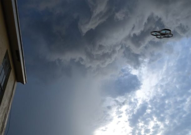
Commercial drones have made their name by observing the world below. Now a new class of missions is moving the aircraft up into the atmosphere itself. The Utah Division of Water Resources is exploring drone-based cloud seeding to replace the crewed aircraft it tested from 2022 to 2025. That puts unmanned aircraft at the meeting point of aviation, meteorology, autonomy and water infrastructure
In this guest post, Andrew Verda, CEO and founder of Utah-based Alto Cirra, argues that the aircraft is only one piece of the system. He explains why meteorology, measurement and BVLOS progress will decide whether drone cloud seeding becomes a real operational tool. He also makes the case that atmospheric UAS may deserve a category of their own in the drone industry.
DRONELIFE does not pay or accept payment for guest posts.
By Andrew Verda, Alto Cirra Founder and CEO
For most of the commercial drone industry, the value proposition has centered on observing the world below: inspecting infrastructure, mapping land, monitoring crops, filming construction sites, or delivering packages.
But one of the more interesting emerging applications for unmanned aircraft may involve operating in the atmosphere itself.
Cloud seeding is hardly a new technology. Programs across the western United States have used ground-based generators and crewed aircraft for decades to introduce ice-nucleating particles into suitable winter storms. What is changing is the aircraft.
Unmanned aircraft can potentially make cloud seeding more targeted, more repeatable, and eventually more scalable—while creating an entirely new class of missions at the intersection of aviation, meteorology, autonomy, and water infrastructure.
That shift is already beginning.
Utah, for example, has operated cloud-seeding programs since the 1950s. The Utah Division of Water Resources says it is now exploring expanded drone-based cloud-seeding technology after testing crewed aircraft between 2022 and 2025. The state describes one advantage of UAS as the ability to fly directly into clouds and release seeding material where temperature and atmospheric conditions are favorable.
For the drone industry, the larger story is not simply cloud seeding. It is what happens when drones move from observing weather to actively operating inside it.
Why Use a Drone?
Traditional cloud-seeding systems generally fall into two categories.
Ground generators release seeding material and depend on winds and atmospheric conditions to carry that material into the desired portion of a cloud. Crewed aircraft can place material much closer to a target area, but aircraft operations introduce cost, crew requirements, logistical constraints, and additional exposure during winter weather.
UAS occupy an interesting position between those approaches.
A drone can be launched relatively close to a target area, sent to a specific altitude or atmospheric region, recover, and potentially fly again during the same storm cycle. Sensors aboard the aircraft can also provide data on temperature, humidity, location, and other conditions during the mission.
Most importantly, the aircraft can potentially go where the meteorological opportunity is rather than relying entirely on the atmosphere to bring the seeding material where operators want it.
The Utah Division of Water Resources describes drone operations as allowing more precise targeting inside clouds. The state currently seeds only during qualifying winter precipitation events; cloud seeding cannot create storms or precipitation from clear skies.
That distinction matters.
Cloud seeding is not about manufacturing weather. It is about attempting to influence the microphysical process occurring inside an existing cloud when the necessary atmospheric ingredients are already present.
In winter operations, that may involve introducing silver iodide particles into areas containing supercooled liquid water. Because silver iodide has a crystalline structure similar to ice, it can act as a nucleus around which ice crystals form.
Those crystals can then grow and potentially fall as snow.
The aircraft, therefore, is only one component of the system.
The harder problem is knowing when and where to fly it.
The Drone Is Only as Useful as the Meteorology Behind It
As UAS platforms become more capable, atmospheric operations may increasingly resemble a closed-loop system.
Meteorological data identifies a potential opportunity.
Models determine where favorable conditions are likely to exist.
Sensors aboard the aircraft verify conditions in flight.
The aircraft deploys material at the targeted location.
Radar, flight telemetry, atmospheric measurements, and ground observations are then used to evaluate what happened.
This is the model we are working toward at Alto Cirra, a Utah company I founded focused on drone-enabled atmospheric operations.
Our work centers on using fixed-wing VTOL aircraft, meteorological modeling, onboard sensing, and targeted deployment systems to explore how UAS can support winter cloud-seeding programs.
But the more interesting part of the problem is not simply putting a flare on a drone.
It is building the data and operational system around the aircraft.
If drone-based cloud seeding develops into a meaningful operational tool, the industry will need to answer difficult questions around atmospheric sensing, mission planning, fleet coordination, verification, airspace integration, and—perhaps most importantly—measurement.
Measuring What Happened Is the Hard Part
Cloud seeding has an unusual measurement problem.
If snow falls after a mission, how much of that snowfall would have occurred naturally?
Weather systems are inherently variable. Two storms that appear similar can produce very different outcomes.
That makes attribution considerably more difficult than measuring the performance of a typical drone mission.
The industry therefore needs to resist the temptation to treat every successful snowfall event as proof of effectiveness.
Utah itself describes evaluating cloud-seeding effectiveness as one of the field’s major challenges. In 2026, the state launched additional research involving high-resolution atmospheric measurements, modeling, and trace-chemistry analysis intended to improve understanding of both effectiveness and environmental impacts.
That kind of measurement work could become especially important as drones make it possible to collect much more granular mission data.
A UAS can produce precise flight tracks, timestamps, deployment locations, sensor measurements, and operating conditions.
Combine those datasets with weather radar, snow gauges, atmospheric models, and ground sampling, and researchers have a much richer dataset than simply knowing that a generator was turned on somewhere upwind of a mountain.
In my view, this data layer may ultimately be as important as the aircraft itself.
The Regulatory Challenge Is Significant
Flying a drone through winter mountain weather is not the same as operating a quadcopter over a construction site.
These missions may involve significant altitude, terrain, low visibility, icing concerns, rapidly changing wind conditions, and flights that could benefit substantially from beyond visual line of sight operations.
Under current FAA rules, Part 107 operators generally must maintain visual line of sight unless they receive the appropriate waiver. The FAA requires operators seeking waivers from normal Part 107 limitations to demonstrate how they will maintain an equivalent level of safety through alternative procedures or technology.
That means the future of atmospheric UAS operations is tied closely to the broader industry’s progress on BVLOS.
Detect-and-avoid technology, command-and-control reliability, remote operations, redundant communications, airspace awareness, and aircraft reliability are not abstract regulatory questions in this application. They directly determine how useful a drone can be during a storm.
State regulations add another layer.
In Utah, cloud-seeding operators must obtain permits and provide an operations plan, target-area information, insurance documentation, seeding methods and materials, and criteria for suspending operations under certain conditions.
The result is an application that sits at the intersection of two regulated worlds: aviation and atmospheric operations.
That complexity will probably slow deployment.
It may also produce better systems.
A New Category of Drone Infrastructure
There is a tendency within the drone industry to organize the market by aircraft use case: inspection drones, delivery drones, agricultural drones, defense drones.
Atmospheric UAS may eventually deserve their own category.
Cloud seeding is one application, but many of the underlying technologies have broader relevance.
Aircraft capable of operating safely in difficult atmospheric conditions could collect high-resolution weather observations in places where conventional sensing is limited.
Distributed fleets could help meteorologists sample the lower atmosphere at greater spatial and temporal resolution.
The same technology stack—rugged aircraft, autonomous navigation, atmospheric sensing, remote operations, and real-time modeling—could eventually support research, wildfire monitoring, severe-weather observation, environmental measurement, and other missions.
Instead of simply carrying a camera, these aircraft become mobile atmospheric sensor platforms.
And in some applications, they may also become tools for interacting with the environment they are measuring.
The Opportunity—and the Responsibility
Drones have already changed what is economically practical in industries ranging from surveying to cinematography.
Atmospheric operations could be another step in that evolution.
But the opportunity comes with a responsibility to separate technological capability from scientific evidence.
Better aircraft do not eliminate the need for good meteorology.
More precise deployment does not automatically prove better precipitation outcomes.
And autonomy does not eliminate the need for strong aviation safety systems.
The exciting part is that UAS make all three problems—deployment, measurement, and repeatability—more approachable.
Cloud seeding provides an unusual glimpse into what that future might look like.
Instead of drones simply documenting the physical world, we are beginning to see aircraft that can navigate dynamic atmospheric environments, gather data from them, make increasingly sophisticated operational decisions, and perform useful work inside them.
That may ultimately be a much bigger development than cloud seeding alone.
More information is available at Alto Cirra.
Read More
About the Author
 Andrew Verda is the founder and CEO of Alto Cirra, a Utah-based company developing unmanned aircraft and atmospheric operations technology for cloud seeding and water-resource applications. His work focuses on the intersection of UAS, meteorology, autonomous flight, and mountain water infrastructure. Verda is also a professional skier and outdoor creator, giving him a firsthand perspective on the connection between western snowpack, mountain communities, and water resources.
