


This article published in collaboration with JUIDA, the Japan UAS Industrial Development Association.
JUIDA-coordinated teams flew indoor searches at Aeon Mall Kumamoto, mapped Yatsushiro and Mashiki by fixed-wing aircraft and drone, then combined SAR satellite data with AI to build a common operational picture for responders.
The Japan UAV Industrial Development Association (JUIDA) published a daily log of its 2026 Kumamoto earthquake response. The log covers activity through August 6, 2026. JUIDA-D³, the association’s civil disaster unit, coordinated field work across six industry members. From August 7 onward JUIDA will post updates only when there are new activities.
JUIDA drone response day by day
The Japan Ground Self-Defense Force Western Army called in JUIDA on July 28. FALCON moved a JUIDA liaison from Fukuoka Airport to Kengun Garrison. Blue Innovation, Liberaware and Terra Labo readied equipment overnight.
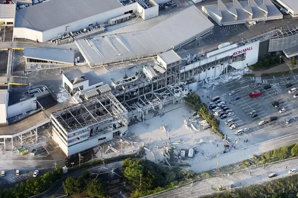
On July 29, Liberaware ran six IBIS2 indoor search flights inside Aeon Mall Kumamoto. Terra Drone joined with one Terra Xross flight. Blue Innovation reached the site. Terra Labo ferried two survey aircraft from Nagoya to Kitakyushu Airport. Eams Robotics prepared for the Kumamoto Prefectural Office.
On July 30, work expanded to the Nippon Paper Yatsushiro Mill. Liberaware ran one indoor search there. Blue Innovation and Terra Drone continued indoor search at Aeon Mall and captured overhead imagery. Terra Labo produced orthophotos of Hikawa and Yatsushiro. Eams Robotics briefed the Disaster Medical Assistance Team and coordinated JAXA-linked manned and unmanned aircraft integration.
On July 31, ACSL provided technical support to the Ground Self-Defense Force 8th Division. Terra Labo shot aerial survey imagery over Kashima-machi and Yatsushiro. JUIDA moved to a remote D³ headquarters. Blue Innovation, Liberaware and Terra Drone stood down and returned to base.
Terra Labo carried the remaining sortie tempo. Fixed-wing aircraft flew low-altitude measurement over southern Yatsushiro and Mashiki on August 1. On August 3 the company combined SAR satellite imagery, aircraft measurement and AI analysis to grade damage. That pipeline layers all-weather radar with higher-resolution optical data. On August 4 Terra Labo released a Common Operational Picture, a shared situational map for disaster response agencies. Data refinement continued through August 5.
Equipment on scene
Blue Innovation deployed two Flyability ELIOS 3 confined-space drones, one DJI Matrice 350 and one Skydio X10. Liberaware fielded two IBIS2 units. Terra Drone brought two Terra Xross aircraft. Terra Labo operated its verification survey aircraft. More information is available at JUIDA.
Read More
